Monday, March 29

Iron Mountain Trail


Continuing with our monthly series, "Adventures With Uncle Bob-Guide to Self-Adventure in Southern Illinois," we feature Iron Mountain trail in Shawnee National forest. This trail was described in the Sierra newsletter Sept, 2006 but did not get posted to the website or lost. Here it is again.
Directions: from Alto Pass, IL, continue south on rt 127 and turn left onto Mt Glen rd (sign for Walnut Grove church). Proceed a couple miles to turn right on Kaolin Road. Follow this to a right turn on kaolin Pit lane. Follow to next right turn and parking lot.
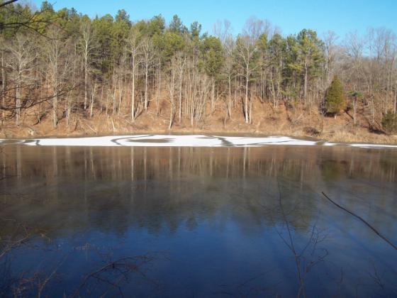
Note the large pond surrounded by ravines. This used to be a mining area for kaolin clay and a company town. After the resource was depleted, it was turned into a fishing pond. Books show a loop trail starting with the overlook near the parking lot. As of this date in January, 2010, that trail segment fizzles out after a quarter mile. The Forest Service plans to reconstruct it this spring. Instead, backtrack east down the road to the white cross and commence this trail segment to the top of the 700 ft mountain. Most of this is a gradual climb and while there are no FS trail signs, the tread seems clear. Note the 1889 ornamental grave stone along the climb. As we ascend, note the deep ravines on both sides of the trail. Near the top, the trail is steep for 100 ft. Now we reach a "T" junction with a north-south trail. Go left (mark this junction so you can find it on the way back). Enjoy the ridgetop views over surrounding valleys and six wildlife pond pits as you travel.
Come to a junction. Turning right brings us to a boundary with Myers Ranch farm -"welcome to pass thru, not responsible for accidents." Note the picnic table in the middle of the trail. Come back to the junction and turn left for more views. Another side trail noted with a sign for Myers horse loop. Pass by an old house foundation from the 1930s. Eventually the trail starts descending into thick woods. I retraced the route back to the car and estimate 1.4 miles from the parking lot to the summit. Another road access to the summit trail is off rt 127. Instead of turning onto Mt Glen Rd, continue past the bridge to an unmarked left turn onto a steep gravel road (FS 606). It is no longer maintained and often deeply rutted. You may need a high clearance vehicle for this. GPS coordinates are N 37.516161 and W 89.311754. More information from Bob Tyson at 684-5643 or robkay43@webtv.net. 10/01/11: the loop is more clear now.hiking past the picnic tables,going up the hill,the trail is headed north. Along the way,look carefully for a left turn where you follow to the top.this used to be blocked by vegetation. Miss this turn and you will continue straight on and will fizzle out.

Thursday, February 25

Hitching Post Trailhead


Continuing with our monthly series,"Adventures With Uncle Bob-guide to Self-Adventure in Southern Illinois," we feature the River to River trail section (trail 001) between Herod, IL and Garden of the Gods. This description will start near Herod, although you can embark either way. Directions: From Harrisburg, take Rt 145 south to Rt 34 and follow to Herod. Near the post office turn left onto the blacktop and travel uphill approx 1.5 miles to the well-maintained Hitching Post parking lot (on the left). It is not signed from the road so watch closely. There is plenty of room for horse trailers. Cross the road and commence the hike. This stretch of Shawnee National forest wilderness area is 5.8 miles.

The trail starts out as a FS fire lane and soon becomes a backbone trail with deep ravines on both sides. We come to a junction with #00lE. Go straight ahead or else you will be going in a circle. Later we find ourselves along a beautiful two-layered cliff line. After that, the trail gets more rugged as it ascends via switchbacks. We finally level out on a steep ridgetop and the trail thru the woods is clearly defined. Be on the lookout for at least four places where one can step off the trail onto rock glades for unimpeded overlooks over the valley and adjacent ridgetops. If you went no further than this point, the hike would be worthwhile. Approx GPS reading here is 37 36' 30"N and 88 24' 0"W. we have hiked about 2.5 miles at the best overlook.

We start a long descent and, at the valley floor, please note the trail junction sign. By now your sense of direction has diminished. Trail 001 points to G.O.G. and Herod. We can continue on #001 but there is a more scenic connecting trail (152A) which will eventually meet back up with #001. While trail 152A is not easy to follow during leafoff, you are rewarded with a tall cliff line on both sides of the trail in a narrow corridor. At some point we rejoin #001 and enjoy views of the cliffs below the main observation trail. Note an "H" shaped window arch about 50 ft up the cliff. As we continue on, you will note forks in the trail to either ascend to the Garden of Gods parking area or continue on to the backpacker parking lot. As of this writing on Nov 24, 2009, the trail was not muddy and suggests that views are optimal during leafoff.

If readers plan a group outing on this trail, regulations limit the group to 10 people or horses. This trail runs thru a designated wilderness area in Shawnee National Forest. For any questions, contact Bob Tyson at 618-684-5643 or robkay43@webtv.net. You may also contact John O'Dell at 618-252-6789.

Monday, January 25

South Atwood Ridge Trail


Continuing with our monthly series, "Adventures With Uncle Bob-Guide to Self-Adventures in Southern Illinois," we feature Atwood Ridge in Shawnee national Forest. Directions: From Jonesboro, IL, take Rt 127 south for approx 4 miles to turn right on Old Cape Plank road. Go 4 miles on this road as it gives way from farm land to forest. It becomes a canyon road thru deep ravines. This is worth the drive even without doing the trail. Look for a sign on the road which reads Trail 264A/1050E. Turn right and at a split, turn right again and start an ascent on this one lane gravel road. Note a parking lot as well as room for 3 cars opposite it (in case the lot is muddy). We will be walking on this gravel lane the whole distance.

From here the road makes a steep ascent. You can also avoid this first ascent by driving up further to some solid shoulder roadside parking just past the bushes lining the road. The road levels off here and there while continuing to ascend this mountain. Note the deep ravines on both sides as you continue to climb. There are frequent points where you can see distant ridgetops and valleys. Near the end, the road descends and then back up again to its end and space to turn around. I noted a narrow dirt trail continuing from here and without any information, walked a short distance without noting anything of significance. The Forest Service knew nothing of the latter. They indicate that this road was built to augment the logging industry and have no other plans for it.

This outing is best during leaf-off or when fall colors come out. More info from Bob Tyson at 684-5643 or robkay43@webtv.net. While here, why not also drive over to Hamburg Hill Trail on Plank road. Information is on this blog as well as the website: http://illinois.sierraclub.org/shawnee/unclebob/adventures.htm.


Wednesday, December 30

Thacker Hollow Trail


Continuing with our series "Adventures with Uncle Bob - Guide to Self-Adventure in Southern Illinois," this month we feature Thacker Hollow. This trail starts at Hurricane Bluff, 1/4 mile east of High Knob trail (scroll down this blog to both places and directions). We follow #106A as it steeply descends the valley after the bluff line. Near the bottom we travel in a canyon between continuous scenic cliff walls on both sides. One problem in this area shows Forest Service directional signs with trail numbers, while equestrian groups put up their directional signs with different numbers on the same route. Due to poor drainage in wet weather, we note horse damage in many places on the trail. We also circumvent downfalls.


#106 ends and we go left on #180 at a junction. Later the cliffs give way to a valley with extremely high ravines on both sides of the trail. At the next junction, go right on #104 (changes to 107). Note the moss-covered cliff walls. We arrive at a junction noted on the green interim trails map as "Initial Tree." GPS coordinates are 37 36' 25"N and 88 17' 47"W. A horse high line is available. Trail #150 on the right heads south. We continue east on trail #005 and blessed with a continuous 45 degree angle cliff lines, 300 ft rock shelter, 35 ft deep shelter cave, and slot canyons. At some point we are on private property (with permission) and come to Blackridge Road. Turn left and walk up the road to follow this cedar glade as far as desired. Shortly, we can turn right off the glade and bushwhack to the north end of Rim Rock trail. Note the staircase. Signs suggest that it is 3.5 miles from where we parked to Initial Tree.


The above description was with a group from the River to River Society. At a later date I went by myself to see if there was a shorter less strenuous route to Initial Tree. Starting at Hurricane Bluff, I descended 106A to the first junction and turned right on #180. It ascended to a scenic boulder area and horse highline. Thereafter it continued thru a pine plantation and eventually faded out before it could join #185. I returned to the car and took Blackridge Road (take Karber Ridge Road past High Knob Road) until I found a small parking area for trail #184. This road is very narrow so one cannot just park along the road. The parking area was a rutted mudhole. The map indicates that 185 should join 185 south, then to #150, and on to Initial Tree. This would be a shorter hike and I am in contact with Forest Service about the parking.On May 25 two of us checked out shorter routes and less confusing trail numbers. From lower High Knob parking, follow the River to River trail east for 1.5 mile(trail newly resurfaced all the way to Blackridge road),and come to an old unmarked parking lot.Get off R-R trail which turns south and go straight ahead on #151 a short distance to a junction with trail 150. It forms a junction with a choice of two directions. go straight ahead on 150. This trail has been reconstructed, goes thru a beautiful cliff canyon with moss covered walls, ravines, and brings you to Initial Tree scenic area . It took 50 minutes to here from that old parking area. At that destination you use #005 to go to the scenic rock caves. Another shorter route is to take Karber Ridge Rd,and go past High Knob rd, and look closely on the left for an unmarked road and has a brown sign as FS 714 upon entrance. Go up the hill,turn right to a FS gate on the road. Park here and walk approx 1.0 mile to the forementioned old parking area.

8/27/2011. found another interesting route. instead of parking on #184 on blackridge rd, go another mile south to park where possible at #183. easier to see now that trail gravel is visible. go west on 183 for little more than a mile on the rim trail above deep ravines until jct with #185. turn left (south)on 185 a short distance to join #182. the latter will take you to #005 and into the initial point scenic area. go east along the cliff line,shelter bluffs. when this ends in a field you are meeting blackridge rd. either re-trace your route or walk the road for a mile back to the car. Upon further note, I clocked 0.9 mile from that point on blackridge to go south to the jct with #001( r-r trail).This gives a short route to still experience some of this hollow.

On 12/28/11, two of us found another loop trail of interest. We parked at #184 (has gravel in the parking area now). note 2 unmarked trails plus signed 184: one is a firelane thru pines to thacker cemetary, and the other just joins 184 later. walking west on 184 has a number of switchbacks along pretty steep ravines above or below the trail. Near it junction with 185 after 20 minutes, note this long cliff lines with small caves, strange formations,and curved walls. We continued to the right on 185 just to view more cliff line and then returned to the junction to go south on 185 and enjoyed more of the same for the next 30 minutes until we turned left onto trail 183. The latter ascends gentilly uphill back to Blackford rd, turn left and walk O.3 mile to the car. Trail tread was excellent. While walking back to the car, we noted trail 105A. We checked it out and found it to be a shortcut to #185: However, it was very steep and rocky.


More info from Bob Tyson at 684-5643 (robkay43@webtv.net) or John O'Dell at 252-6789

Monday, November 23

Bell Smith Springs


Continuing with our series, "Adventures with Uncle Bob - Guide to Self-Adventure in Southern Illinois," we feature the trails in Bell Smith Springs this month. Directions: Go east from Marion on Rt 13, take Rt 166 thru Creal Springs to US 45, turn right and travel to Ozark, turn at the sign for Bell Smith Springs, and go about 12 miles (turns to gravel the last 4 miles).

At the parking lot, let's turn left on the blue-signed Sentry trail. This has level grade most of the time except for a couple swithbacks. This affords continual rim views into the canyon, which are optimal during leafoff. Initially, there is a Jay's Gap sign to descend to the bottom and access the yellow Natural Bridge trail or to walk along the base of the cliff line west to another staircase to the top. Continuing on the Sentry trail, we cross Chute Gap, which is a cascade flowing between rock walls. 1.5 miles later, Sentry trail descends to the creek. Note the cave on your right-about 20 ft deep, 5' high. At this date the creek was 2 ft deep and I didn't feel like going barefoot at 60 degrees; However, blue markers are noted across the creek as one ascends to the other side to continue the loop. I returned to the parking area junction and proceeded on the white signed trail on the right-going west.
This trail will split: the white continues as a rim trail for a half mile and descends to the trailhead for Mill Branch trail (scroll this blog index for Mill Branch). At the split, I descended the staircase to another white sign base trail which follows a pretty cliff line, turned left at a split and continued under frequent rock overhangs. The trail ends at a sign which says "not maintained beyond this point."

Retuning to the area near the staircase, I find the yellow trail for Natural Bridge. This will involve a creek-crossing without stepping stones. After crossing, look to the right for rock stairs. At the cliff line one can either go right to the base of the bridge or climb the metal rungs for a loop traversing the top of the bridge. This has a span of 120 ft and 22' height. The closest GPS coordinates are 37 31' 0"N and 88 39' 0"W. Another picture of the bridge is at http://www.naturalarches.org/db/arches/illinois.htm (replace Illinois with any state to view other arches). Beyond this site, we are on the blue Sentry trail again (south side). The rim top trail has constant views of cliff walls, opposite the creek. Note the caves and rock shelters. At some point after the trail changed direction, the markers vanished and no obvious path. I returned to the parking lot. Even with the difficulty of making a loop out of the loop trail or avoiding creek crossings, this place is worth your effort. More info from Bob Tyson at 684-5643 or robkay43@webtv.net. During a Sierra hike November,2010,after a summer drought,we were able to make both creek crossings on stepping stones. The first crossing as noted above,is correct for the loop.After doing so,climb up the rocks and the rest of the loop trail will be visible upon turning to the right.

Friday, October 23

FS 747 Trail


Continuing with our monthly series, "Adventures with Uncle Bob-Guide to Self-Adventure in Southern Illinois," we feature the above trail. Directions: In Murphysboro, take 20th street south out of town to Hickory Ridge Road. Follow for several miles to a 4-way stop. Turn right and travel to Fairview Church. The parking area is on the right. This was the scene back in the 80's when there was a long-term protest by environmental groups against East Perry Lumber and Shawnee National Forest.
The trail is an old Forest Service road, traversing continual views of deep ravines on both sides of the path. We encounter rock outcroppings several times. The trail steeply desends to a narrow creekbed. Note a spur trail on the righ whch frequently crosses acreek with some nice views. A long ascent follows to a point where we can see Fountain Bluff in the distance. Eventually we descend to a utility right-a-way and electric tower. The trail goes steeply downward to an open field. I retraced the path back to the car. This trail is worthwhile during leaf-off and the distance out and back is approx 2.5 hours. Avoid this one after frequent rains and also becomes overgrown in the summer and fall. Since this is not an official FS trail, it is not maintained.
Subsequent to this visit, I was here after our May wind storm and downfalls block the entry point of the trail. The picture, above, shows an example of serious erosion along the trail. More info from Bob Tyson at 684-5643 or robkay43@webtv.net

01/28/2012: forget this trail as the forest service has no plans to repair the trail and is too much work for volunteers to handle the trees on the trail.

Tuesday, September 22

Cedar Bluff Trail


Continuing with our series, "Adventures with Uncle bob-Guide to Self-adventure in Southern Illinois," we feature Cedar Bluff trail and a side trip to BORK'S WATERFALL. Both are on Illinois Dept of Conservation land. Take I-57 south from Marion, Ill. to Lick Creek exit. Go east thru the village, continuing about 5 miles, and come to a junction. Turn left and go to Cedar Grove Church parking lot. The trail starts in the woods on your right. It will gradually ascend for 0.3 mile to a junction with the bluff line. The cliff walls average about 80-90 ft and include several rock shelters. Note the wavy texture of the rock formations and pattern lines. Turn left and follow the cliff line until the trail ends at the private property line. Come back to the junction and continue straight ahead on this trail segment along the cliff line. It will end at approx 0.3 mile. Note the 3 story, free-standing boulder, as well as a path to the top of the cliff (don't try this when the soil is wet and slippery). At the top, turn left, and bushwhack a short distance to an unobstructed view over the valley and adjacent ridgetops. This is a major rapelling area. Return to the car.Coordinates are N37.521718 and W-89.022851.


Take Cedar Grove road north from the church about 6 miles (first 3 are paved) and note a parking lot just before a stream which flows across the road. One choice is to walk over the stream and take the rim trail on the east side of the chasm. At some point you will see an obvious place to drop to the bottom of the cliffs and go to the base of the falls. Another choice is to descend the R-R trail by the parking lot and enjoy the cliff lines as you descend on this service road to the bottom. Then turn left at the clearing and pick up the base cliff trail to the waterfall. This flows over a wide shelter bluff and approx 50 ft. Another access to the falls is available by taking Goreville exit on I-57, go east and turn right on Regent Road.coordinates at the waterfall are 89 1' 19.44"w and 37 32' 29.41"N


More info from Bob Tyson at 684-5643 or robkay43@webtv.net