Iron Mountain Trail

Continuing with our monthly series, "Adventures With Uncle Bob-Guide to Self-Adventure in Southern Illinois," we feature Iron Mountain trail in Shawnee National forest. This trail was described in the Sierra newsletter Sept, 2006 but did not get posted to the website or lost. Here it is again.
Directions: from Alto Pass, IL, continue south on rt 127 and turn left onto Mt Glen rd (sign for Walnut Grove church). Proceed a couple miles to turn right on Kaolin Road. Follow this to a right turn on kaolin Pit lane. Follow to next right turn and parking lot.
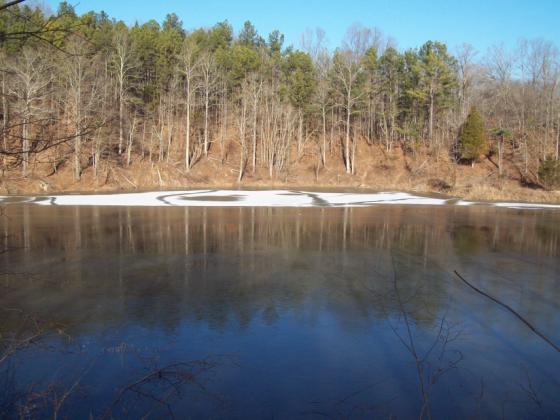
Note the large pond surrounded by ravines. This used to be a mining area for kaolin clay and a company town. After the resource was depleted, it was turned into a fishing pond. Books show a loop trail starting with the overlook near the parking lot. As of this date in January, 2010, that trail segment fizzles out after a quarter mile. The Forest Service plans to reconstruct it this spring. Instead, backtrack east down the road to the white cross and commence this trail segment to the top of the 700 ft mountain. Most of this is a gradual climb and while there are no FS trail signs, the tread seems clear. Note the 1889 ornamental grave stone along the climb. As we ascend, note the deep ravines on both sides of the trail. Near the top, the trail is steep for 100 ft. Now we reach a "T" junction with a north-south trail. Go left (mark this junction so you can find it on the way back). Enjoy the ridgetop views over surrounding valleys and six wildlife pond pits as you travel.
Come to a junction. Turning right brings us to a boundary with Myers Ranch farm -"welcome to pass thru, not responsible for accidents." Note the picnic table in the middle of the trail. Come back to the junction and turn left for more views. Another side trail noted with a sign for Myers horse loop. Pass by an old house foundation from the 1930s. Eventually the trail starts descending into thick woods. I retraced the route back to the car and estimate 1.4 miles from the parking lot to the summit. Another road access to the summit trail is off rt 127. Instead of turning onto Mt Glen Rd, continue past the bridge to an unmarked left turn onto a steep gravel road (FS 606). It is no longer maintained and often deeply rutted. You may need a high clearance vehicle for this. GPS coordinates are N 37.516161 and W 89.311754. More information from Bob Tyson at 684-5643 or robkay43@webtv.net. 10/01/11: the loop is more clear now.hiking past the picnic tables,going up the hill,the trail is headed north. Along the way,look carefully for a left turn where you follow to the top.this used to be blocked by vegetation. Miss this turn and you will continue straight on and will fizzle out.

