 Continuing with our series,"Adventures With Uncle bob-Guide to self-adventure in Southern Illinois", we feature Camp Ondessonk trails. I am re-printing a previous article which appeared on a defunct website. Directions: From Marion,ill.,take rt 13 east to rt 166, go thru Creal Springs to us 45, turn right and follow to Ozark. Turn left into town and note the Camp Ondessonk sign and arch. Follow about 3 miles to St noel administration building. Check in here for permission to proceed to the camp parking lot. no dogs allowed. This is usually closed to hikers from mid-May thru mid-September. If you are taking a group in here to hike on a weekend, call first; another group may have reserved the whole place(618-695-2489); Otherwise, just come during a weekday should be no problem.
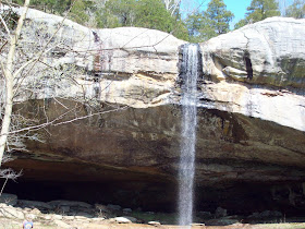
Cross the covered bridge. The first stop is a short trail below the dining hall/chapel to see the big shelter bluff which serves as an ampitheater. a seasonal waterfall over the bluff may occur. Go back up and follow a road east, turn by the tree house bunks and follow this beautiful cliff line. Be sure to visit each slot canyon grotto for fantastic views. Later, a dead end side trail goes up wooden steps with a semicircle cliff line and waterfall. Back on the trail, the road forks. Let's turn uphill and then another switchback. Now we are on an old rail bed for approx one mile. Upon noting an old horse barn, start looking for a user-made trail on the right to descend to Cedar Falls. GPS coordinates 37 30' 60"N and 88 44' 17"W. On 02/17/12, it had a drop of 80 ft over the top of this scenic bluff line.
Return back to the fore mentioned fork in the road. Turn left and follow to a beautiful cascade over 5 ledges. Continue on the levee road to a swinging bridge, cross and back to the parking lot. For a top view of the falls, you can drive east from Ozark and note a sharp curve, turn on a road going south (road sign has the word "tuck" on it) and follow to the end at the gate. An obvious short trail will take you to the top of the falls and cliffs. Any questions, contact Bob Tyson at 684-5643 or robkay43@webtv.net.

No comments:
Post a Comment